Thursday 30 May 2013

Mount Hood

It had rained all night at our campground and so when we set off to continue our drive around Mount Hood this morning we were wondering if the highest mountain in Oregon had seen some snow.

A short detour up towards Timberline Lodge and we didn't have to guess...  Snow Snow Snow!!!

Timberline is a year-round ski lodge/resort but the snow wasn't just on the upper slopes where the chairlifts continue to go in summer time, it was everywhere!!

With views of Mount Hood appearing and disappearing every few seconds behind fast-moving cloud, we made the most of the fresh powder, having some serious snowball fights, and checked out a few skiers and snowboarders carving it up.

(Indy and Dash are yet to try skiing/snowboarding so we enjoyed whetting their appetite for when the chance arises and are happy to report they're super keen).

Continuing anti-clockwise around the mountain we joined the 35 and after passing through a heavily forested zone with numerous ski resorts (not all-season) left and right of the road, we reached lower elevations.

Here we found some of the most beautiful territory we've seen so far - a valley filled with idyllic orchards set against the backdrop of snow-capped Mount Hood.

We stopped at a panoramic overlook for lunch before continuing to Hood River, a gorgeous hamlet on the Columbia River.

We drove a small stretch beside this mammoth river to Cascade Locks where we have found a campsite and settled in for the night.


Wednesday 29 May 2013

Boys' Day Out in Portland

After a big effort from the boys on our hike yesterday we felt it was time to make good on the lesson that sometimes we do things that parents like to do and sometimes we do things that kids like to do.

So we spent a few hours this morning at a family fun centre riding go karts, playing in the indoor playground and driving arcade games like Mario Kart.

As if that wasn't mega-awesome enough, we had lunch at Denny's and THEN went to Walmart so the kids could spend their pocket money.

With the kids occupied by their new purchases (gee $7 goes a long way over here!) Nath and I decided to check out the Portland city centre from the comfort of Bessie.

After spending all of 20 minutes driving through Portland city I feel confident (cough!) in saying that there's a big time university-town, grungy vibe to the place.

There's also something wacky going on Eg. There was a line 20-people deep out the door of a place called Voodoo Doughnuts.

Are they really just selling doughies? Can the doughies really taste THAT good?

Either it's a front for something else or there's a tendency here to jump on the latest bandwagons.

Even on the outskirts we saw a Japanese sushi takeaway place (very small joint) with a cast of thousands waiting to get through the door.

Voodoo doughnut's byline was something like "the hole is where the magic happens". Mmmmm still not convinced.

Portland also has a HUGE number of nudie bars in residential areas. Just an observation.

And yes, lots of bridges!

We finished the day by heading out on the 26 south west towards volcanic Mount Hood.

We grabbed a campsite at the forestry service's Tollgate Campground - and have the whole campground to ourselves tonight and a massive set of raging rapids on the river right beside us! Nice!

Tuesday 28 May 2013

Silver Falls State Park

To say we were astounded by our hike today in Silver Falls State Park is to put it mildly. This State Park tucked back away from the Oregon coast not far from the capital of Salem, is an absolute treasure.

We saw one incredibly beautiful waterfall after another on a walk that wasn't in any way, shape or form strenuous, yet had the trail mostly to ourselves (seeing only 10 other hikers the whole time).

We're certain the place must pump with tourists come summer, and so maybe we scored on the timing front, but we're still pinching ourselves about the beauty we've encountered today in virtual privacy.

Everything is cloaked in the vivid greens that only a wet, mossy environment can support, yet with super tall forest trees all around.

You can even walk behind several of the waterfalls which is pretty rare (without getting your feet wet or impaling yourself on fallen logs).

We had driven into the park yesterday, unsure of what to expect, and found a really lovely campsite in heavy rain and so bunkered down until morning (albeit with electricity - thanks Oregon State Parks!)

This morning, in only light drizzle, we set off to do most of the Trail of Ten Falls, taking in seven of the big boys. And by 'big boys' I mean that Indy started counting the little rivulets running down mountainsides and got to ten 'waterfalls' before we'd even seen our second major set of falls, so there's a lot of water running every which way for the eyes to take in.

We made the hike more of an adventure for the boys by spending ample time behind the 'mystical' water falls making magical wishes, and by picking salmonberries the whole way (which were abundant).

At one stage I found myself yelling out apologies to the area's bears because I'm sure Dash ate enough to rob them of dessert for a few nights.

Starting at the South Falls, we took the Canyon Trail to Lower South Falls and then the North Canyon Trail to Lower North Falls.

We detoured to Double Falls, then back to Drake Falls and Middle North Falls.

Nath left us just after crossing the river and he powered on ahead to Winter Falls and then took the trail back to Bessie at South Falls, while the kids and I kept plodding away, finishing up ourselves at Winter Falls (a total of seven kilometre for the boys - which is a record for Dash on his own two feet and not far off Indy's best, which remains still the 10km walk he did with James and Alex at Thredbo -- there's nothing like peer pressure to make a kid want to keep hiking!!)

After Bessie the Bus picked us up, we enjoyed lunch at an overlook with views to North Falls before leaving the park and driving through more idyllic agricultural land dominated mostly by Christmas Tree Farms.

Monday 27 May 2013

Oregon Coast


Windblown, wet, rocky crags dominated most of the Oregon Coast we’ve been travelling through the past few days.

On our first day we crossed the border and followed the scenic 101, taking the detour to Sunset Bay State Park and staying in a county park for the night.

We were talking to a local guy at the playground and thanks to his great tip, took the kids down to the Sunset Bay rock pools the next morning and had a really interesting ramble over the rocks at low tide – finding anenomes, sea stars, hermit crabs and other cool stuff exposed.

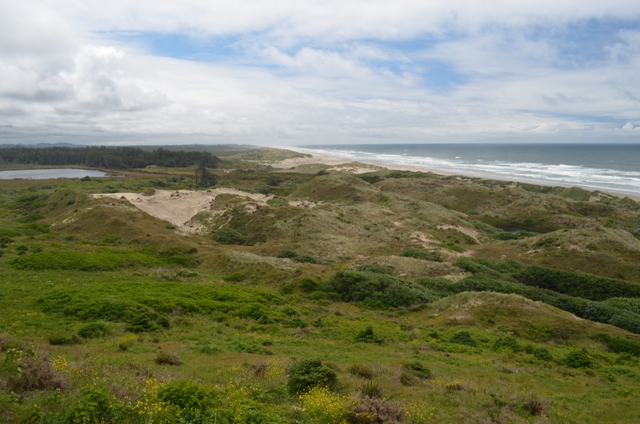
The next section of the drive, from Coos Bay/North Bend northwards was dominated by massive coastal dune systems.

Some of these were solidly covered by forests. Others were exposed and completely devoid of anything but grasses and yet others were crawling with ATVs enjoying the Memorial Day Weekend in recreational areas set aside for their play.

We couldn’t believe some of the set-ups these families have – their trailers are filled with enough vehicles for every member of the family (even kids as young if not younger than ours). The family that rides together stays together I guess!

There were also a huge number of lakes and lagoons either side of the road and we camped beside one of these lagoons (an ‘oxbow’ lake) in the Siltcoos Recreation Corridor.

The next morning, as we headed further north, we avoided the Sea Lion Caves that we’d read were a bit over-touristed and instead pulled into the Heceta Head Lighthouse State Scenic Viewpoint and admired the vista across a small bay to the really gorgeous lighthouse.

We watched the seals swimming through the waves below and sunning themselves on the exposed rocks.

Indy was using his binoculars (a very thoughtful xmas gift from the Roddas) and offered a group of lady travellers a look through them.

They peered through (probably just to humour him) and exclaimed, “Oh, these are real. Oh LOOK! There ‘s the seals!”, to which Indy replied, “Yeah, but don’t try my brothers. They’re toy ones.”

When we pulled in at the Cape Perpetua Scenic Area Visitors Centre, we decided to find a site at the campground (and did, right beside the river).

We were in luck with the tides and went straight down to the beach to catch the high tide pounding up through thor’s well, the devil’s churn and a natural sea geiser that looked really cool shooting the ocean mist high into the air with each of the big crashing waves.

Nath ran up to the Cape Perpetua Overlook for views along the coast before getting our fire started just as the almost-constant drizzle started again.

The boys gorged themselves on the salmonberries they had picked on the trail and at our campsite.

This state park is just one of several along the shoreline we’ve seen so far in Oregon. In fact, there’s almost continuous parks management where the land meets the sea.

I’m wondering if it’s perhaps because so much of the Oregon coastline is dominated by state and forest parks that it has retained such a real sense of isolated wilderness for the most part.  

The next morning, we kept following the rugged, windswept coastline north to Newport. Here, we visited the Hatfield Marine Science Center of the University of Oregon.

Indy’s favourite exhibit was a wave tunnel that allowed him to construct buildings from Lego and then send waves down the tube (either regular, irregular or Tsunami) to where his constructions stood.

Up until yesterday he’d been talking about being a photographer but now there’s a lot of questions being thrown at us about building materials. Maybe a construction engineer?

If there’s one thing we want for the boys as much as their good health it’s that they’ll find a passion in life and get the chance to follow it.

Indy has developed a REALLY full-on obsession with Carbonara (yes, the sauce) which Nath has been making up whenever we’ve got the ingredients. Indy grunts like a pig hunting truffles and says “Thankyou Thankyou, you’re the BEST dad!” over and over as he eats it.

So we’ve tried to explain our hopes for him this way.... “Indy, we hope that one day you love your work as much as you love carbonara.”

Wednesday 22 May 2013

Redwood State and National Parks

Driving up through the Avenue of the Giants (as this side road off Interstate 101 is known north of Fort Bragg) was a dwarfing experience.

No matter how many of California's massive trees you encounter, you still can't help feeling awed in the presence of so many massive trees.

In this part of the world, where the road cuts straight through a swathe of them, you get to check them all out without even leaving your vehicle(!)

And so we had a great drive and then camped at an RV park at Eureka (the town was a hole but the RV park had a hot tub that the four of us spent half an hour in -- it's like the bath we'd never had!)

The next morning we headed into Redwood National Park (which is actually a conglomeration of state parks and national parks rolled into one).

The campsite we found at Elk Prairie lived up to its name with a huge number of elk welcoming us. Our site was a pearler, right beside a little stream and the perfect location while light rain kept us 'indoors' for the rest of the day.

Today we took a hike - a loop made up of the South Fork, Rhododendron and Brown Creek Trails - about 5.5km total. The boys were little champions and even had enough energy to race each other over flat sections towards the end of the hike.

We saw four banana slugs and discussed how much more like a 'rainforest' this zone seemed compared to the other giant tree zones we'd visited further south.

The boys had completed Junior Ranger activities and so at the northern end of the park, were awarded their Redwoods Junior Ranger badges.

We are now camped just north of Crescent City and deciding what to do. We had planned to head towards Crater Lake Nat. Park next but have just seen online that snows have closed the access roads and campgrounds.

This has been a constant on our trip so far - we're skirting the edges of the open seasons at the places we're going to and sometimes we've been lucky and other times not (eg. lots of great looking campsites have been 'closed for the season'). We may end up just staying put until we decide which way to go next.

Monday 20 May 2013

Napa and the Sonoma Coast

After finding a county park campground on the eastern side of Napa township, we headed north along the 'Silverado Trail', taking in America's finest wine-growing region (as the spiel would have you believe).

We used our imagination as to what the experience might be like for those people who spend their day being driven around in the multiple stretch limos we saw, stopping at one fine vineyard after another, leisurely sampling one beautiful wine after another, no doubt accompanied by exquisite delicacies prepared by world-renowned chefs.   Mmmmmm.

That's not what we did.

But hey, we can still tell you that the area is really lovely - a very beautiful day's drive in fact (we just didn't stop in at any of the wineries which are kind of the crux of the whole region!)

Okay, so as you drive, you cruise past one beautiful vineyard after another and I don't know about anyone else, but I find there's something so peaceful and comforting about the way they manage to get those vines so straightly lined up - maybe it appeals to the obsessive compulsive lurking inside.

We found Yountville for a fun play in a great little playground and shock-horror, the kids were labelled 'mean boys' for the first time I can remember. A little girl had tried to tell them (admittedly, in a fairly bossy way) that they were using a play thing incorrectly and they told her to leave them alone and that they were brothers and she couldn't tell them what to do. Cue little girl sobbing hysterically and screaming "they're being mean to me!!!" Then the parents got involved. Way to fly the Ossie flag boys!

Reaching Calistoga, we turned west and then followed Hwy 29 down in the opposite direction. Some of the towns along the way are truly exquisite in a pristine for-the-tourists kind of way whereas Calistoga appealed to us with its more grounded, real vibe (while still lovely).

There was a real lack of campgrounds in this region and we ended up driving back up well north of Sonoma to Sugar Loaf Ridge State Park before we found somewhere.
The next morning we were up and out heading west towards the coast when we got caught up in detours in effect for the Tour of California which was heading through the area. We passed through some beautiful grazing land and rolling hills as a result before hitting the coast at Bodega Bay.

Back on Highway 1 we worked our way slowly up the coast, taking in the rugged scenery as far north as Fort Bragg and camped the night at MacKerricher State Park.

The next morning, Nath took a run with Indy riding his bike beside him back towards Fort Bragg along a disused rail line converted into a foot trail (about 5km return). Dash and I took a scoot down to the seal watching platforms but didn't sight any.


Thursday 16 May 2013

Sacramento

The California State Railway Museum here in Sacramento is really impressive. A lot of effort has gone into making the exhibits look truly realistic.

My favourite was a sleeper car from the mid-20th century complete with the rocking motion and dim lighting you would have experienced on board travelling at 50mph in the middle of the night. I even started whispering so as not to disturb the sleeping guests in their bunks.

There's a great playroom with Thomas and Chugginton play tables and a toy train exhibit on the second floor.

There are heaps of information boards and exhibits covering the creation of the first transcontinental railway (one of the wonders of the modern era) but I didn't get to take many of those in - the boys were way too excited to stand still at just one exhibit.

The only disappointment in the place was the bodgerama 20-minute film that was meant to be about how the railway transformed life in the west but was like a bad 80s soap opera done in period costume.

A quick walk through the old town and waterfront area showed us that they've done an impressive job restoring this zone to a goldrush-era look, with the timber floorboard shopfronts and wide dirt 'roads' etc.

I would have liked to visit the museum that covered the gold rush but the kids were getting jumpy.

So we went back to where we'd parked Bessie and instead checked out the Red Bull Xtreme Sports Motocross action that was kicking up dust directly beside us.


Wednesday 15 May 2013

Lake Tahoe

After 7 days of dry camping we drove into the Lake Tahoe area and finally managed to get a bit of reception.

Only then did I find out I'd missed most of Mother's Day! Doh!

Never fear... the boys took me out for a delightful dinner at Denny's - is there anything better?

We found a campsite at the South Lake Tahoe City campground and spent a couple of nights there while we restocked and washed etc. A great nearby playground and ample chances to bike/scoot kept the kids amused.

We explored a little of the eastern (Nevada) side of the lake before heading north along the west coast, stopping in at Emerald Bay along the way.

The fact that all state and forest campgrounds around that side of the lake were still closed ('for the season') was a disappointing surprise and as rain started to fall, we turned away from the lake.

Heading for truckee, north west of the lake, we came across a great little forest campground that was actually open.

We took an awesome little site right beside the river and with hardly anybody else in the campground, we decided to stay put for a couple of nights and just enjoy the serenity.

The boys made a little boat and floated it down the river on a string. Even after hours fighting the rapids it still managed to come out in one piece!

And an industrious beaver kept making his way upstream to grab some twigs and branches and then would float his way back down with the current and into a burrow hidden on the banks across from us. 

Saturday 11 May 2013

Tioga Pass


Green with envy over Nath's hike yesterday, I set out today to do a quick return trip to the upper yosemite falls overlook and yosemite point for myself (14.4km return).

Nath kindly dropped me at the trail head and then took the kids back to Happy Isles (where I'd taken them the day before).

On their return, they waited for me with Bessie parked just near the lower yosemite falls.

The spot had lovely views of the falls and the kids enjoyed playing in the meadow.

I totally saw what Nath had been saying. It was nice to see the valley from that northern side. (Five years ago we did a loop down into the valley that started and finished at Glacier Point on the southern side and this walk provided a very different perspective).

I think it's a shame that most people seem to stop at the Falls overlook and don't continue on to Yosemite Point which offered much more spectacular views.

On the way back down, I heard a classic statement from a young guy (shirt off) who was half-way up and telling his friend:
"Man, I'm a bullet. They're probably like 'hey, where'd he go', but you know I just like to smash it out right".

Yes, yes, you are a bullet and you are other things too.

Once I was back down, we pulled out and felt like incredibly lucky ducks driving over the Tioga Pass on opening day. B-eaut-i-ful!!

So much snow! So divine!

And we weren't alone in thinking so. The number of professional photographers with their heavy equipment and massive tripods at every turn was testament to how pure and untouched this landscape looked (being uncovered for the first time since winter).

We stopped many, many times for snowball fights and photo taking and general vista admiring. And beyond the eastern exit of the national park, found a forest campsite not far from a stream.

Goodbye Yosemite! We'll be back!


Friday 10 May 2013

Upper Yosemite - North Dome - Valley Floor Loop

(By Nath)...

Of the 3.5 million people that visit Yosemite National Park each year, 3.45 million of them never leave the valley floor.

Escaping the crowd was the motivation behind taking on this golden 29-kilometre trail, starting with a heart pumping two-hour ascent up yosemite falls (about 1km altitude gain), leaving all the lard asses behind.

You wouldn't read about it, but when I got to the top, there was a tightrope stretched across the top of the thundering falls.

What did I do? Took off my boots, strapped on my cowboy hat, and gave it a go of course (see photo - I had some Italian dude take my picture).  

After that I continued along the northern rim of Yosemite to the mighty North Dome and for three hours didn't encounter another soul. A lot of the forested section of the trail was still covered in snow... I just powered through Rocky IV style, visualising the defeat of Ivan Drago. 

I totally underestimated the amount of water I would need, so I ate snow for the last half of the hike. A wise man once told me: 'don't eat yellow snow'... it's always good to have these survival tips on board.

I saw quite a few deer, and c.150 squirrels.  

Followed Indian Ridge for an hour, looking over at the mighty Half Dome. Only rock cairns to guide me over this glorious granite ridge. I didn't see any Indians though.

After seven hours I started the descent following Snow Creek looking up Tenaya Canyon... my knees/quads are made for descending... no sissy hiking poles here.  

8.5 hours round trip.  Chowed like a horse, drank 2L water and 5 x Budweiser when I got back to Bessie.

The boys took turns at knee dropping on me as I passed out into a deep sleep.


Thursday 9 May 2013

Yosemite encore

Is there any better indication that a place is awesome than the fact you want to visit it again and again? We've just left Yosemite for the second time and are now imagining the things we're going to do on our NEXT visit!

Let's back it up a little bit...

We drove into the park in the late afternoon and found the site we'd booked for 3 nights at the Lower Pines Campground on the Valley floor (one of the rare times we book anything - and it's lucky we did because it was the only site left!)

It was an awesome site too - 10 meters to the river and 20 meters to the shuttle stop with great bike riding/scooting space to boot.

Come morning, I downed a coffee before setting out on foot walking/jogging my way upstream along the Merced River to Happy Isles and then following the horse trail up Tenaya Creek to Mirror Lake and back home again (about 6.5km).

On the way out I was clapping and whooping every now and again to warn bears of my approach but soon stopped it on the mirror lake section when I realized how busy a trail it was. There's nothing cooler than yelling out and then rounding a bend to find a school group!

Later we caught the shuttle bus to check out the visitor centre and lower yosemite falls. Spectacular falls but a real circus (fantastic people-watching). 

That afternoon, knowing what Nath had planned for himself the next day, I set out to explore the Merced River heading west and ended up following trails for almost 11km. I stood very still watching deer extremely close up for some of the time which was nice.

But I was unfortunately way too far from Bessie and nowhere near shuttle stops when a freak hail storm pelted down on me and so I did a lot more sprinting than I'd intended!! But all's well that ends well (that is, me getting back safe and sound).

Wednesday 8 May 2013

Kings Canyon and Sequoia National Parks

Before I tell you about our time in these National Parks, can I just take a moment to share how much I adore country and western music, which is all we've been able to pick up in the more remote areas we've been travelling through in this past week.

My absolute favs so far are:
- a love ballad by Brad Paisley which features the line "I'd like to check you for ticks"
- George Strait's Here For a Good Time where he requests "To hell with the red wine, pour me some moon shine"
- and the sure-to-be-a-classic by Jason Aldean who sings "And I can take you for a ride on my big green tractor". Song title in case you're wondering: Big Green Tractor.

Okay, so we have been skirting on the very edges of winter conditions and were lucky enough to have access roads open up with very nice timing for us to explore Kings Canyon and Sequoia National Parks. 

What this means is while the roads have mostly been okay to drive (apart from the snow storms we've  had) we have been limited to where we could camp (most campgrounds are still covered in snow) and it has been COLD. 

Massive upsides of course are having the parks mostly to ourselves and the chance to see them at their most wintery wonderland best, with a fair bit of spring melt thrown in just to make the rivers ultra-impressive. A very good trade-off I think.

KINGS CANYON

We drove straight in on the 180 and found a campsite at Azalea Campground in the Grant Grove Village area of Kings Canyon. This was our base for 2 nights and the only campsite cleared and open in that national park (incidentally though, it was possible to free camp by parking on roadside pull-outs in the national forest controlled sections and some of those areas on the 180 were really nice beside Kings River).

On our first full day in the park, we drove the 180 down into Kings Canyon, checked out the Roaring River Falls and took a stroll around the Zumwalt Meadow loop. As we were hiking back to Bessie, the skies darkened and from that point onwards for the next 24 hours we had snow falling almost continuously. When we got back up out of the Canyon, we found the visitor centre and bought a book about tracks and scat (poo) - is there anything more interesting? - and took a short walk around General Grant, the world's third largest tree (by volume that is - there are ones out there that are taller or wider).

SEQUOIA

Waking up at our site, with everything draped in white was lovely (as unaccustomed as we Aussies are to it) and we set off down the 198 into Sequoia National Park where we found the world's largest tree. Yes, the very biggest one out there apparently. Although I tend to question whether people know about every single tree that exists in the entire world and wonder if, somewhere out there, there are bigger ones that aren't so look-at-moi.

Anyway, after we thoroughly spoiled the other tourists' experience of the General Sherman Tree, with our kids fighting with each other the whole time, we thought to go and unleash ourselves on the Lodgepole Campground. 

In the still-falling snow, Nath took a run up to the Tokopah Falls (5.5km return) while the boys and I listened to the Kaweah River flowing directly past Bessie.

With Nath raving about the trail, the following morning in welcome sunshine we all set off along the same track, now checking for tracks and scat with our new-found knowledge. Basically we are always on Poo Patrol now.

We saw some deer and porcupines and heard woodpeckers at work. No bears (fortunately) but given how much noise the boys make, I doubt we're going to surprise one on the trail.

The trail was indeed lovely and Nath was surprised by the views of high peaks around us that he'd missed in the falling snows of the previous day.

By lunchtime we were back at Bessie and hauled out back down the 198/180 and then north.